NASA's Aqua satellite identified powerful thunderstorms around the center of Cyclone Garry as the storm continued to intensify over warm waters of the South Pacific Ocean. Garry has prompted warnings for the southern group of the Cook Islands.
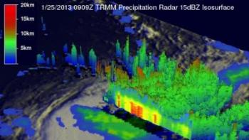
 NASA's TRMM satellite saw tropical cyclone Garry moving through the open waters of the South Pacific Ocean on Jan. 25, 2013, at 0909 UTC. The heaviest rainfall (red) was occurring in Garry's eastern quadrant at a rate of 2 inches (50 mm) per hour. Credit: SSAI/NASA, Hal Pierce
When NASA's Aqua satellite passed over Cyclone Garry the AIRS instrument captured an infrared image of Garry's clouds, providing temperature data to forecasters at the Joint Typhoon Warning Center (whom forecast tropical cyclones in that region). AIRS, the Atmospheric Infrared Sounder instrument, showed that there was a large area of powerful thunderstorms where cloud tops were so high that they were as cold as -63 degrees Fahrenheit (-52 Celsius). Those thunderstorms were producing heavy rainfall over the open waters of the Southern Pacific Ocean.
Cyclone Garry appeared to be near its peak on Jan. 25 when the storm's maximum sustained winds reached 85 knots (97.8 mph/157.4 kph). At 0900 UTC (4 a.m. EST) Garry's center was located near 16.6 south latitude and 160.2 west longitude, about 515 nautical miles (592.7 miles/953.8 km) west of Bora Bora. Garry was moving to the southeast at 15 knots (17.2 mph/27.7 kph).
Warnings and Watches Posted
The Fiji Meteorological Service has issued storm warnings for the southern group of the Cook Islands that include: Rarotonga, Aitutaki, Mangaia, Atiu, Mauke, Mitiaro, Palmerston, Manuae and Takutea.
A storm warning is in effect for Aitutaki, Manuae, Takutea and Atiu. Sustained winds of 60 knots (69 mph/111.1 kph) with higher gusts can be expected as Garry approaches and passes. Garry is expected to generate high seas and heavy rainfall that could produce flooding in low-lying coastal areas. A gale warning is in effect for Mauke, Mitiaro, Mangaia and Rarotonga. Squally thunderstorms with heavy rainfall may cause flooding in low-lying areas. Garry is expected to bring sustained winds of 40 knots (46 mph/74 kph) with higher gusts and rough seas.
A strong wind warning is in effect for the rest of the southern Cooks. Strong southeast winds with average speeds of 25 to 30 knots (28.7 to 34.5 mph / 46.3 to 55.5 kph) are expected with squally thunderstorms and periods of heavy rainfall. Seas are expected to be rough, and some low-lying flooding is possible. For updates on warnings and watches from the Fiji Meteorological Service, visit: http://www.met.gov.fj/current_warnings.php
NASA's TRMM Satellite Measures Heavy Rainfall in Garry
NASA's Tropical Rainfall Measuring Mission (TRMM) satellite saw tropical cyclone Garry moving through the open waters of the South Pacific Ocean on January 25, 2013 at 0909 UTC (4:09 a.m. EST). Tropical Cyclone Garry was classified as a category two tropical cyclone on the Saffir-Simpson hurricane scale a couple hours earlier but had started to weaken when TRMM flew over. Sustained wind speeds were estimated to be less than 85 knots (~98 mph) and Garry is forecast to continue weakening while moving toward the southeast.
TRMM's main mission is to measure rainfall over tropics but has frequently been useful for monitoring tropical cyclones. The rainfall data compiled on Tropical Cyclone Garry was from two TRMM instruments. Rain rates in the Garry's center were taken from the TRMM Precipitation Radar (PR), the first precipitation radar in space, while rain rates in the outer swath were taken from the TRMM Microwave Imager (TMI). The heaviest rainfall was occurring in Garry's eastern quadrant at a rate of 2 inches (50 mm) per hour.
TRMM's Microwave Imager (TMI) is a passive microwave sensor designed to estimate rainfall in an 878 km (~545.6 miles) wide area by measuring the amount of microwave energy emitted by the Earth and its atmosphere. TRMM PR has a horizontal resolution at the ground of about 5.0 km (~3.1 miles) and sees a strip of the earth that is 154 miles (247 kilometers) wide.
TRMM PR can peer through obscuring clouds and provides 3-D vertical profiles of rain and snow from the Earth's surface up to a height of about 12 miles (20 kilometers). The 3-D and rainfall imagery is created at NASA's Goddard Space Flight Center in Greenbelt, Md.
Steering the Storm
The upper levels of the atmosphere are a major factor in the life and behavior of a tropical cyclone. Forecasters at the Joint Typhoon Warning Center (JTWC) analyzed the upper levels of the atmosphere above Garry and found that the system is deeply embedded in the prevailing westerly winds. Those upper level winds are contributing to Garry's intensification.
By Jan. 27, a trough (elongated area) of low pressure is expected to approach Garry and change its direction to a more east-southeasterly direction.
As Garry moves further to the south, forecasters at JTWC expect vertical wind shear to increase and make the storm decay. Garry is expected to become an extra-tropical cyclone over the next couple of days and become a cold core low by Jan. 29.