Sep 11 2014
The Eastern Pacific Ocean continues to turn out tropical cyclones and NASA's Aqua satellite caught the birth of the fifteenth tropical depression on September 10 and shortly afterward, it strengthened into a tropical storm and was renamed Odile.
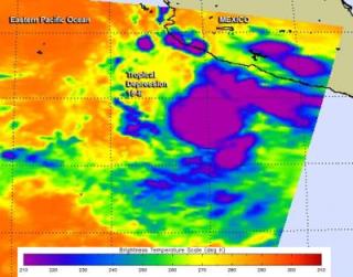
 This false-colored infrared image from NASA's Aqua satellite captured the birth of Tropical Depression 15-E on Sept. 10 at 8:53 UTC. Credit: Image Credit: NASA JPL, Ed Olsen
The Atmospheric Infrared Sounder or AIRS instrument that flies aboard NASA's Aqua satellite captured infrared data on Tropical Depression 15-E on September 10 at 8:53 UTC (4:53 a.m. EDT) when it developed. The National Hurricane Center named the depression at 5 a.m. EDT, when the center was located near latitude 14.4 north and longitude 102.5 west.
AIRS infrared imagery reads temperature and identified the coldest temperatures in powerful thunderstorms circling the center of the newborn depression. Cloud top temperatures were near 220 kelvin (-63.6F/-53.1C).
By 11 a.m. EDT, the depression strengthened into Tropical Storm Odile. Maximum sustained winds were near 40 mph (65 kph) and Odile was drifting toward the north-northwest near 3 mph (6 kph) and is expected to drift to the north-northwest over the next two days. Odile was located near 14.9 north latitude and 102.9 west longitude, about 220 miles (350 km) south-southwest of Lazaro Cardenas, Mexico.
The National Hurricane Center noted that on the forecast track, Odile's center will remain offshore of the southwestern coast of Mexico through Thursday night, September 11. However, Odile is expected to create swells, rip currents and rough surf along the southwestern coast of Mexico over the next day or two.