Jun 3 2016
A breakthrough wireless sensor network has been designed by a Universidad Politécnica de Madrid (UPM) research team for prevention and extinction of wildland fire.
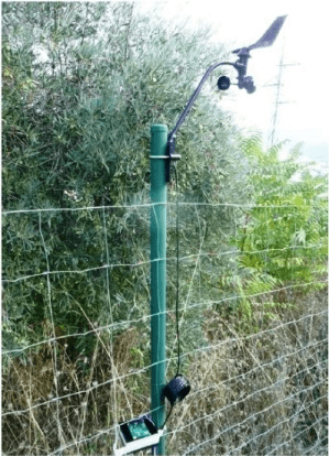
 Sensor node equipped with anemometer and wind vane. / Álvaro Araujo. (credit: Universidad Politécnica de Madrid)
The research group, named the B105 Electronic Systems Lab group from UPM, is working on the development of innovative technologies that provide protection to forests by reducing the risk of forest fire and minimizing environmental damage. As part of this research project, the team has developed the new wireless sensor network that can measure environmental variables and yield useful information in real time. This knowledge can help combat wildland fire.
One of the major environmental problems in Spain is wildland fires due to their climatic and geographical variables. Nearly 12,000 fire incidents occurred in the country in 2015 and burned over 100,000 hectares of land, as per the data reported by the Ministry of Agriculture, Food and Environment (Spain).
Researchers have created a multidisciplinary system called PROMETEO for preventing these disasters and for performing fire extinction safely and efficiently. This national R&D project receives data from various sources, including ground sensors, aerial means, and satellites, which helps in the prevention and extinction of wildland fires.
Centre for the Development of Industrial Technology (CDTI), along with a consortium of 15 companies and other public research institutes from various Spanish universities, promotes PROMETEO. The group of B105 Electronic Systems Lab, from School of Telecommunications Engineering at UPM, together with GIICA group from Universidad Politécnica de Valencia (UPV) and ISDEFE Company, has contributed to the development of the ground sensor network.
This network comprises tiny, low power sensor nodes to measure environmental variables, including soil moisture, temperature, and wind direction and speed. In addition, these sensor nodes feature a wireless interface and a small processor for data transmission. After the deployment of the sensor nodes on the ground, a network is automatically created by them to route the wireless measurements and messages to the central node. After receiving from all the nodes, the central node transmits the data to the control center, which also receives the ground data from other sources such as terrain models, fire behavior, historical weather data, and satellite.
This information can be applied in two different stages by the organization responsible for combating fires. The first stage is the prevention stage that uses the data to identify potential locations at high risk of fire. This data is used to take necessary measures for preventing fires and continuously updating the ground models. In the second stage, if a fire incident occurs even after these preventive measures, the system data can be used for fire extinction as the system transmits real-time data pertaining to the spread of fire. As a result, the team responsible for extinguishing the fire can perform safer and more efficient fire extinction works.
The research work on the ground sensor network has been described in Journal of Sensors.