May 22 2019
A set of diode-based LIDAR instruments recently developed by researchers could aid in bridging the significant gaps existing in meteorological observations and spur a leap in modeling, understanding, and predicting climate and weather.
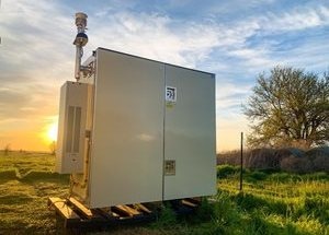
 Micro-pulse DIAL (MPD) #1, of a network of five, deployed at the ARM Southern Great Plains atmospheric observatory in north-central Oklahoma. (Image credit: Catharine Bunn)
In particular, the instruments are suitable for gaining a better understanding of atmospheric dynamics at the mesoscale—a size range corresponding to the area of a tiny city up to that of a U.S. state.
A research team from the National Center for Atmospheric Research (NCAR) in Boulder, Colorado and Montana State University (MSU) in Bozeman will discuss the study during The Optical Society’s Optical Sensors and Sensing Congress, which will be held from June 25th to 27th in San Jose, California, during Sensors Expo 2019.
To date, the researchers have developed five diode-based micro-pulse differential absorption LIDAR (DIAL) instruments, also known as MPD instruments, in order to profile water vapor in the lower troposphere—the atmospheric region where most weather takes place. Diode-laser-based instruments work in the range of 650 to 1,000 nm wavelengths, predominantly within the infrared spectrum. It is possible to deploy these instruments both day and night and, moreover, they can be mostly unattended without causing any damage to the humans’ eyes.
The network of five water vapor MPD instruments was deployed to the atmospheric radiation measurement Southern Great Plains atmospheric observatory in mid-April. From this three-month field experiment we will gain insight into how weather forecasting may be impacted by continuous MPD measurements of atmospheric water vapor.
Catharine Bunn, Team Member, Department of Physics, Montana State University
Filling monitoring gaps
In the past 10 years, the National Academies of Sciences, Engineering and Medicine and other expert team wrote a number of reports that have identified a major requirement for vertical measurement profiles of temperature, aerosols, and humidity in the lower troposphere. Experts have also proposed for the development of a “network of networks” for gathering and sharing this information. To give the required coverage for better climate and weather forecasting across the United States, one report recommended deploying a range of sensors on the ground at approximately 400 sites across the nation spaced about 125 km apart.
Conversely, there existed a gap in the instrumentation to fulfill this goal for monitoring and research without depending on aircraft-based devices, which are costly to deploy. Based on previous work performed by other research teams and teaming up with NCAR researchers, MSU instrument developers focused on diode-based MPD technology as a low-cost method to a profiler that can perhaps make accurate measurements and meet the required specifications for unattended and continuous operation and eye safety.
Demonstrating value in the field
Five different instruments based on a standard architecture were created by the researchers. In this standard architecture, laser pulses are transmitted to the atmosphere and the return signal is determined with single photon counting modules. This return signal changes as the light interacts with water vapor. All the five instruments are operational and a couple of them have been deployed in ground-based climate- and weather-research experiments.
One specific instrument, which was collaboratively designed by NCAR and MSU researchers, was fielded as part of the Front Range Air Pollution and Photochemistry Experiment, or FRAPPE for short. This instrument determined the vertical profile of water vapor with a mean error of less than 10% across a range of atmospheric conditions, as opposed to profiles gathered by airborne devices. In addition, the instrument operated unattended for 50 continuous days at the time of FRAPPE without any obvious reduction in performance, offering roughly 95% data coverage.
The team has also progressed toward vertically profiling temperature and aerosols—the two high-interest aspects of the lower troposphere. NCAR scientists, on the basis of the MPD architecture, developed an innovative high spectral resolution LIDAR (HSRL) that has the potential to profile aerosols. Supplementing this work, a physicist at MSU modified mathematical methods from quantum mechanics to resolve an equation that paves the way to utilizing measurements of properties of atmospheric data, including oxygen molecules, to produce a vertical temperature profile. Preliminary experiments and models propose that apart from determining water vapor and other airborne particles, the HSRL is capable of providing the measurements required for high frequency and fine-grained temperature profiling.
During the Optical Sensors and Sensing Congress, the researchers have planned to provide the latest updates about their temperature profiling work as well as other updates on their instrumentats.
For now, Bunn stated, “We are beginning to retrieve temperature profiles of the lower troposphere with an accuracy of +/- 2 Kelvin and we are working to improve instrument and retrieval algorithm performance.”