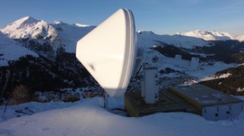
A team of researchers from the Environmental Remote Sensing Laboratory (LTE) from EPFL have completed a two year field study in the Swiss Alps around Graubünden in an effort to gather data to accurately determine intensity of snowfall using remote sensing.
 LTE Laboratory in the Swiss Alps
Local meteorological conditions can influence the intensity of precipitation, especially in mountainous regions, where the uneven terrain affects wind patterns and the distribution of humidity and temperature. In such cases, remote sensing helps predict natural hazards such as avalanches.
In rain intensity measurement, a brief radio wave pulse is transmitted by a radar into rain, snow, planes or birds or other obstacles. The radar receiver picks a section of the signal that bounces back and determines the amplitude, time lag, frequency of the returning signal in order to determine the size, distance and speed of the obstacle. Although the use of radar waves to measure the intensity of rain is reliable, it is difficult to use the same principle on solid forms of precipitation.
Professor Berne and his team from the LTE lab have used an advanced dual-polarization X-band Doppler radar to gather radar images from Jakobshorn. Ground based snow data was provided by researchers at the Snow and Avalanche Research which corresponded with the information gathered by the LTE researchers over 2 years.
The X-band Doppler radar transmits two linear orthogonal polarizations of radio waves simultaneously while traditional weather radars transmit a single polarization. The researchers then study the returning signal to determine the shape of the obstacle encountered by the radio waves. The data collected over the last two years is being studied to determine snow type and snow intensity and can form the basis for further research.