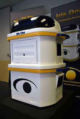
Visual Intelligence in collaboration with MaxVision has developed an airborne image processing and digital sensing system, the Iris One.
 Iris One from Visual Intelligence
The breakthrough digital sensing system is a modular, upgradable and scalable solution best suited for homeland security, military and commercial use. Providing extremely accurate sensor and image data, the affordable Iris One can be deployed in unmanned and manned air vehicles.
Adapting COTS technology to facilitate rapid enhancement and deployment, the Iris One provides high resolution images. The architecture of the Iris One, the Arca, is scalable, small, light and powerful that can accommodate near infrared and color and camera modules as well as fuse/ integrate other remote sensing systems that are configurable using software modules and plug-n-play hardware modules.
The software applications complementing the Iris One include the Isis Earth and the Isis Sky. The onboard ortho processing capability is provided by Isis Sky, while real-time ortho processing is provided by Isis Earth. For the processing demands of software applications, Visual Intelligence collaborated with MaxVision for the MaxCubeII Super-Server solution, a feature-rich mobile server that enables low power consumption along with computational capabilities required by the Isis Sky and Isis Earth to support Stereo DEM Generation, Sensor Data Fusion, Ortho Mapping and other sensitive applications. The MaxCube II also provides extreme data processing and storage capabilities required by the Iris One solution.