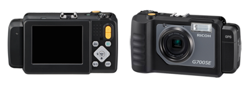
Geo Tactical Solutions has announced that the company has recently collaborated with the Long Beach Police Department to test the capabilities of its G700SE-M Rugged Tactical GPS camera to geo-tag operational photographs with high accuracy while embedding the GPS coordinates and important attribute data for describing the photos. The GPS enabled G700SE-M was tested in an operational security sweep drive along with officials from the police department.
 G700SE-M Tactical GPS camera
The main objective behind the operation was to secure the Long Beach Harbor area prior to the arrival of China’s Vice President, Xi Jinping. The LA Fire Department and the Long Beach Harbor Police also collaborated in the operation to secure the harbor areas by investigating several areas of the shipping vessel.
The advanced memo features and GPS capabilities of the camera enabled operators to collect the GPS coordinates of the objects they photographed, which included pier posts and propellers, and tagged each photograph with the attribute data such as operator’s name, operation type, GPS date as well as time. The embedded information plays an important role during photo mapping, reporting, post-processing and on occasions when the photographs are submitted as evidence or proof in litigation cases.
The photographs collected during the security sweep were uploaded to the GTS photo mapping software, PhotoGIS and were processed for geo-location accuracy. Using PhotoGIS, officials can generate reports, distribute them and export the digital images for GIS programs such as GeoSuite, Google Earth, ArcGIS and TIGR for further analysis.
The features of the Ricoh G700SE-M Tactical GPS camera include night vision optics to enable round-the-clock operations; resistant to dust, weather, chemicals, water and shock; wireless LAN and Bluetooth capability; SAASM-compatible GPS receiver and bar code reader support