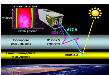
Scientists at Naval Research Laboratory (NRL) have used scans from the Remote Atmospheric and Ionospheric Detection System (RAIDS) experiment and acquired an altitude profile of a dim extreme-ultraviolet terrestrial airglow emission. This provides critical information that is required for enhancing the sophisticated methodologies required for performing remote sensing of the daytime ionosphere.
 This image shows a schematic representation of the dayside ionosphere remote sensing concept, using measurement of the scattered 83.4 nm emission to infer ionospheric densities. Measuring the 61.7 nm emission provides direct information on the intensity of the source region in the lower thermosphere that is currently only modeled for operational algorithms. Photo: U.S. Naval Research Laboratory
The ionosphere that surrounds the Earth consists of plasma that is weakly ionized. It affects over-the-horizon radar, high-frequency communication and other such Navy applications. The new data from RAIDS will help enhance the operational algorithms required for characterizing the global morphology and vertical structure of the ionosphere. RAIDS measurements have earlier been used for calibration and validation of special sensor ultraviolet limb imager sensors in DoD’s meteorological satellites.
The RAIDS experiment consists of eight optical sensors that span wavelengths from the ultraviolet to the infrared. The NRL hyperspectral imager for coastal oceans experiment and RAIDS were flown on the International Space Station Japanese Experiment Module-Exposed Facility as the HICO-RAIDS Experiment Payload. RAIDS has collected more than a million terrestrial airglow scans and is collecting downward-looking spectra.
Researchers at the NRL Space Science Division and at the The Aerospace Corporation analyzed the data from RAIDS as on 29 Oct 2009. This provided an independent test of the model. This is also being used for the daytime ionospheric remote sensing method. Small differences were observed and these confirmed the belief that the doubtfulness about the neutral atmosphere density has limited high-accuracy ionospheric specification. The study results will help remove these limitations and aid in better understanding of the ionospheric region.
The study has been published in the Journal of Geophysical Research.