By Kalwinder KaurSep 26 2012
A wearable sensor system has been developed by MIT researchers. This sensor system automatically constructs a digital map of the wearer’s environment.
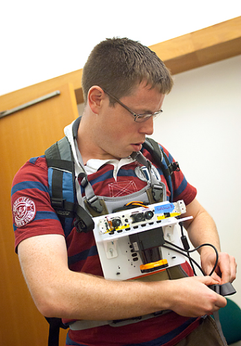
 Maurice Fallon, a research scientist in MIT’s Computer Science and Artificial Intelligence Laboratory, demonstrates how the sensor is worn. Photo: Patrick Gillooly
The prototype system will serve as potential tool to enable emergency responders manage disaster response.
Demonstration at MIT campus showed the wireless transmission of data by sensors to a laptop in a remotely located conference room. The conference room observers successfully tracked the student’s movement on a map.
A handheld pushbutton device, when equipped to the array of sensors, enables the wearer to annotate the map. In the prototype system, pushing of button simply assigns a specific location. Emergency responders can adopt a similar system to complement the map with voice or text tags, denoting toxic spill or structural damage.
The earlier research on systems that facilitate robots to map their environments supports the new work. With several modifications, the sensor system can be made wearable.
Automatic building mapping at MIT
In addition to detecting changes in altitude, the system adopts sensors, like laser rangefinder, sensors in a robot’s wheels, sensor coupled to a platform with a cluster of accelerometers for measuring changes in altitude etc and gyroscopes for interpreting the readings, a camera for capturing the environment, and, even a barometer.
The prototype of the sensor platform includes a handful of devices equipped to a sheet of hard plastic resembling an iPad in size. It is wearable as well as portable.
This initiative was supported by U.S. Air Force and the Office of Naval Research.
Disclaimer: The views expressed here are those of the author expressed in their private capacity and do not necessarily represent the views of AZoM.com Limited T/A AZoNetwork the owner and operator of this website. This disclaimer forms part of the Terms and conditions of use of this website.