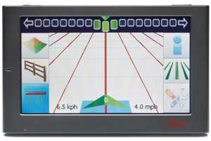
Today Leica Geosystems introduced the Leica mojoMINI 2, a cost-effective, steer-to-the-line solution that provides farmers with an entry point into precision guidance. The Leica mojoMINI 2 is a great solution for anyone looking for an affordable way to start saving money in the field by enhancing driver accuracy and reducing overlap.

The practical and easy to use display is installed in no time and customers can start experiencing its clear menu structure and intuitive navigation right away. It offers two lightbar modes (cross track only lightbar and the Leica Geosystems’ smart lightbar) and support for KML files, which allows users the ability to export their latest work data for viewing in Google EarthTM.
The Leica mojoMINI 2 has an easy-to-use 4.3-inch touch-screen display and comes with a Leica GeoSpective 2 smart antenna and with GL1DE® technology for improved in-field accuracy. The rugged design withstands even the toughest field conditions and provides multiple guidance options, including AB Parallel, A+ Heading, Fixed Contour and Pivot Guidance for use in different field types. Features such as Boundary Recording, Coverage Mapping and Continue Field make the entry-level display a must-have for small farming operations and first-time users of precision guidance systems.
Availability
Leica mojoMINI 2 will replace the established Leica mojoMINI and is planned for release in May.
More information about Leica Geosystems Agriculture products is available from all authorized Leica Geosystems distribution partners and at www.AgGuidance.com.
Google EarthTM is a registered trademark of Google Inc.
About Leica Geosystems’ Ag Guidance Solutions
Whether looking to reduce input costs and increase productivity through more efficient application, or save on time and operator fatigue by lowering the number of passes in the field, Leica Geosystems provides farmers with a suite of simple, reliable and affordable agricultural guidance and precision farming tools.
Leica Geosystems’ Ag Guidance solutions combine state-of-the-art positioning technology with robust, compact hardware built to withstand the toughest field conditions. Compatible with a wide range of vehicles and third party equipment and modular in software design, Leica Geosystems’ products are flexible and scalable to suit individual requirements.