Jul 28 2010
Southwest Research Institute has been granted with a 2010 R&D Award for developing a remote neutrally buoyant sensor, to define a clear path and determine its dimensions and also map out underwater caves and other underground channels and holes.
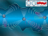
These sensors float through underground channels and caves, and quantify the path, dimensions and morphology of the hole or cavity, by utilizing an array of ultrasound sensors. The data is amassed by recovering back the floating sensor, and is transmitted either physically or remotely to a static sensor, fixed to the land, when the sensor floats alongside.
 Southwest Research Institute has been granted with a 2010 R&D Award for developing a remote neutrally buoyant sensor, to define a clear path and determine its dimensions and also map out underwater caves and other underground channels and holes.
A principal developer of the sensor, and an Institute Scientist in SwRI’s Geosciences and Engineering Division, Dr. Ronald Green, stated that this accumulated data is of vital importance for geotechnical risk assessment and water-resource management This information is of great use in the competent handling of Karst aquifers and also to assess the geotechnical risk factors from these Karst aquifers, if they are present near dams, or when buildings and roads are built on them unknowingly.
The older conventional methods of using divers to map caves, or inserting dyes to find out the route and water flow travel time through underground cavities, can be replaced by using these sensors, as dives are confined to shallow caves, big passages and small distances, being extremely dangerous. The dye tracer tests are also not very accurate.
According to Ben Abbot, another Principal developer of the sensor, and Institute engineer in SwRI’s Automation and Data Systems Division, these sensors are built using readily available components, and so prove to be inexpensive. Due to this factor, many sensors can be used and a successful survey conducted, if the information is collected from one sensor at the end of its sojourn. Its low cost also proves to be useful when the sensors are deployed in difficult surroundings, as even if a sensor is lost, other sensors can be used.
The sensor can also be used to map out completely filled or partially filled pathways, such as pipelines and sewage systems, especially those of small diameters, and whose innards are obstructed by deposits of sediments or get corroded. This is of great use in older cities, where precise records and maps are unavailable, and human access is restricted, due to unsafe conditions. It can also be applied in geotechnical sites such as tunnels and flooded underground mines that are inaccessible to humans because of their dangerous features.
This is SwRI’s 35th R&D 100 Award and will be bestowed on November 11, 2010 in Orlando.