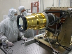
A Lockheed Martin team delivered the first Geostationary Lightning Mapper (GLM) instrument that will provide earlier alerts of developing severe storms and contribute to more accurate tornado warnings. The sensor will fly on the National Oceanic and Atmospheric Administration’s (NOAA) next-generation Geostationary Operational Environmental Satellite (GOES) satellite missions, known as the GOES-R Series.
 The first Geostationary Lightning Mapper instrument, shown here in a file photo, will be launched aboard the National Oceanic and Atmospheric Administration’s next-generation weather satellite missions, GOES-R, starting in 2016.
The team is preparing integration with the first GOES-R spacecraft at Lockheed Martin’s facility near Denver. The satellite is expected to launch in early 2016.
“GLM will have the potential to save lives by using lightning as a reliable indicator of severe weather, like tornados,” said Russell Katz, Lockheed Martin GLM deputy program manager. “A rapid increase of in-cloud lightning can precede severe weather on the ground. Changes in that type of lightning can also give us a better understanding of the updraft strength in thunderstorms.” The instrument also gives us a better understanding of the updraft strength of thunderstorms by capturing changes of the in-cloud lightning.”
GLM provides a new capability to track lightning flashes from geostationary orbit, with continuous coverage of the United States and most of the Western Hemisphere. The heart of the GLM instrument is a high-speed (500 frames per second), 1.8 megapixel focal plane, integrated with low-noise electronics and specialized optics to detect weak lightning signals, even against bright, sunlit cloud backgrounds.
The GLM team leveraged common systems. GLM uses technology developed for the Lightning Imaging Sensor used on NASA’s Tropical Rainfall Measuring Mission. Plus, it sets a new standard for pixel imaging, since it uses a new technique that delivers sharp resolution at the edge of its observable area, compensating for the curvature of the Earth. This benefits future Earth-observing missions from geostationary orbit.
GOES satellites are a key element in NOAA’s National Weather Service operations, providing a continuous stream of environmental information (weather imagery and sounding data) used to support weather forecasting, severe-storm tracking and meteorological research.
The GOES program is managed and operated by NOAA, which establishes requirements, provides funding and distributes environmental data for the United States. NASA’s Goddard Space Flight Center, in Greenbelt, Maryland, manages the GLM instrument development as a part of its support to NOAA’s development of the GOES-R Series of satellites.