Feb 12 2015
NASA-NOAA's Suomi NPP satellite flew over Tropical Depression Higos and saw wind shear is literally pushing the storm apart.
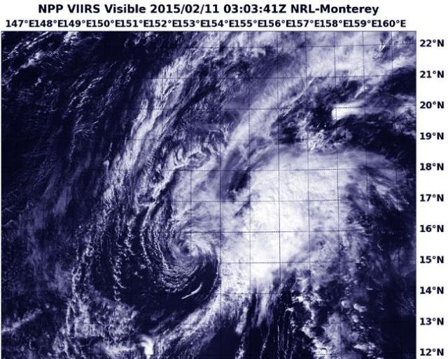
 When NASA-NOAA's Suomi NPP passed over Higos on Feb. 11 at 3:03 UTC this visible image showed that wind shear had pushed the bulk of clouds and thunderstorms east of the center. Credit: NRL/NASA/NOAA
When Suomi NPP passed over Higos on Feb. 11 at 3:03 UTC (Feb. 10 at 10:03 p.m. EST) the Visible Infrared Imaging Radiometer Suite or VIIRS instrument aboard captured a visible image of the storm. The image showed that the bulk of clouds and showers were pushed to the east of the center, leaving just a thin band of clouds around the low-level circulation center.
VIIRS is a scanning radiometer that collects visible and infrared imagery and "radiometric" measurements. Basically it means that VIIRS data is used to measure cloud and aerosol properties, ocean color, sea and land surface temperature, ice motion and temperature, fires, and Earth's albedo (reflected light). The Suomi NPP mission is a bridge between NOAA and NASA legacy Earth observing missions and NOAA's next-generation Joint Polar Satellite System, or JPSS.
On Feb. 11 at 1500 UTC (10 a.m. EST), the Joint Typhoon Warning Center (JTWC) issued the final warning on Higos. At that time the storm had weakened from a typhoon to a depression with maximum sustained winds near 25 knots (28.7 mph/46.3 kph). It was centered near 16.0 north latitude and 152.4 east longitude, about 456 nautical miles east-northeast of Andersen Air Force Base, Guam. It was moving to the northwest at 6 knots (6.9 mph/11.1 kph).
The last update from JTWC noted that Higos was being battered by strong vertical wind shear between 20 and 30 knots (23 and 34.5 mph/37 and 55.5 kph).
Higos was no threat to land areas and was dissipating under hostile atmospheric conditions.