Apr 13 2015
Smartphones and other personal electronic devices could, in regions where they are in widespread use, function as early warning systems for large earthquakes according to newly reported research. This technology could serve regions of the world that cannot afford higher quality, but more expensive, conventional earthquake early warning systems, or could contribute to those systems.
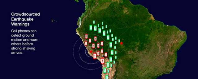
 Crowdsourced Earthquake Warnings. Cell phones can detect ground motion and warn others before strong shaking arrives. Base map originally created by NASA. Artwork credit: Emiliano Rodriguez Nuesch with Pacifico.
The study, led by scientists at the U.S. Geological Survey and published April 10 in the inaugural volume of the new AAAS journal Science Advances, found that the sensors in smartphones and similar devices could be used to build earthquake warning systems. Despite being less accurate than scientific-grade equipment, the GPS (Global Positioning System) receivers in a smartphone can detect the permanent ground movement (displacement) caused by fault motion in a large earthquake.
Using crowdsourced observations from participating users’ smartphones, earthquakes could be detected and analyzed, and customized earthquake warnings could be transmitted back to users. “Crowdsourced alerting means that the community will benefit by data generated from the community,” said Sarah Minson, USGS geophysicist and lead author of the study. Minson was a post-doctoral researcher at Caltech while working on this study.
Earthquake early warning systems detect the start of an earthquake and rapidly transmit warnings to people and automated systems before they experience shaking at their location. While much of the world’s population is susceptible to damaging earthquakes, EEW systems are currently operating in only a few regions around the globe, including Japan and Mexico. “Most of the world does not receive earthquake warnings mainly due to the cost of building the necessary scientific monitoring networks,” said USGS geophysicist and project lead Benjamin Brooks.
Researchers tested the feasibility of crowdsourced EEW with a simulation of a hypothetical magnitude 7 earthquake, and with real data from the 2011 magnitude 9 Tohoku-oki, Japan earthquake. The results show that crowdsourced EEW could be achieved with only a tiny percentage of people in a given area contributing information from their smartphones. For example, if phones from fewer than 5000 people in a large metropolitan area responded, the earthquake could be detected and analyzed fast enough to issue a warning to areas farther away before the onset of strong shaking. “The speed of an electronic warning travels faster than the earthquake shaking does,” explained Craig Glennie, a report author and professor at the University of Houston.
The authors found that the sensors in smartphones and similar devices could be used to issue earthquake warnings for earthquakes of approximately magnitude 7 or larger, but not for smaller, yet potentially damaging earthquakes. Comprehensive EEW requires a dense network of scientific instruments. Scientific-grade EEW, such as the U.S. Geological Survey’s ShakeAlert system that is currently being implemented on the west coast of the United States, will be able to help minimize the impact of earthquakes over a wide range of magnitudes. However, in many parts of the world where there are insufficient resources to build and maintain scientific networks, but consumer electronics are increasingly common, crowdsourced EEW has significant potential.
“The U.S. earthquake early warning system is being built on our high-quality scientific earthquake networks, but crowdsourced approaches can augment our system and have real potential to make warnings possible in places that don’t have high-quality networks,” said Douglas Given, USGS coordinator of the ShakeAlert Earthquake Early Warning System. The U.S. Agency for International Development has already agreed to fund a pilot project, in collaboration with the Chilean Centro Sismológico Nacional, to test a pilot hybrid earthquake warning system comprising stand-alone smartphone sensors and scientific-grade sensors along the Chilean coast.
“The use of mobile phone fleets as a distributed sensor network — and the statistical insight that many imprecise instruments can contribute to the creation of more precise measurements — has broad applicability including great potential to benefit communities where there isn’t an existing network of scientific instruments,” said Bob Iannucci of Carnegie Mellon University, Silicon Valley.
“Thirty years ago it took months to assemble a crude picture of the deformations from an earthquake. This new technology promises to provide a near-instantaneous picture with much greater resolution,” said Thomas Heaton, a coauthor of the study and professor of Engineering Seismology at Caltech.
“Crowdsourced data are less precise, but for larger earthquakes that cause large shifts in the ground surface, they contain enough information to detect that an earthquake has occurred, information necessary for early warning,” said study co-author Susan Owen of NASA’s Jet Propulsion Laboratory, Pasadena, California.
This research was a collaboration among scientists from the USGS, California Institute of Technology (Caltech), the University of Houston, NASA’s Jet Propulsion Laboratory, and Carnegie Mellon University-Silicon Valley, and included support from the Gordon and Betty Moore Foundation.
Caltech is a world-renowned research and education institution focused on science and engineering, where faculty and students pursue new knowledge about our world and search for the kinds of bold and innovative advances that will transform our future.
The University of Houston is a Carnegie-designated Tier One public research university recognized by The Princeton Review as one of the nation's best colleges for undergraduate education.
Carnegie Mellon University is a private, internationally ranked university with a top-tier engineering program that is known for our intentional focus on cross-disciplinary collaboration in research.
Managed for NASA by the California Institute of Technology, the Jet Propulsion Laboratory has active programs in Earth science, space-based astronomy and technology development, and manages NASA’s worldwide Deep Space Network.