Apr 29 2015
Many view Antarctica as a frozen wasteland. Turns out there are hidden interconnected lakes underneath its dry valleys that could sustain life and shed light on ancient climate change.
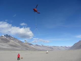
 A helicopter begins a survey with an airborne electromagnetic sensor at Bull Pass in the Wright Valley, McMurdo Dry Valleys, Antarctica. Credit: J. Mikucki
Jill Mikucki, a University of Tennessee, Knoxville, microbiology assistant professor, was part of a team that detected extensive salty groundwater networks in Antarctica using a novel airborne electromagnetic mapping sensor system called SkyTEM.
The research, funded by the National Science Foundation, provides compelling evidence that the underground lakes and brine-saturated sediments may support subsurface microbial ecosystems.
The study is published in the current edition of the journal Nature Communications. It is available through open access.
The findings allow scientists to better learn how Antarctica has responded to climate change over time, said Mikucki, the study's lead author. The findings also help them understand glacial dynamics.
"It may change the way people think about the coastal margins of Antarctica," she said. "We know there is significant saturated sediment below the surface that is likely seeping into the ocean and affecting the productivity of things that feed ocean food webs. It lends to the understanding of the flow of nutrients and how that might affect ecosystem health."
The researchers believe the newly discovered brines harbor similar microbial communities in the deep, cold dark groundwater. The brines may provide insight on how microbes survive such extreme conditions. They also may provide the basis for future exploration of a subsurface habitat on Mars.
Mikucki and the international interdisciplinary team used the airborne sensor to produce extensive imagery of the subsurface of the coldest, driest desert on earth, the McMurdo Dry Valleys in Antarctica. Because a helicopter was used to make the measurements, large areas of rugged terrain could be surveyed. The team found that brines form extensive aquifers below glaciers and lakes and within permanently frozen soils.
The airborne sensor technology was developed at the University of Aarhus in Denmark and was used in Antarctica for the first time during this study.
The team also flew the sensor over the Taylor Glacier, one of the best-studied glaciers in the world. The glacier has a unique feature known as Blood Falls, where iron-rich brine from the subsurface is released at the front of the glacier. The falls is known to harbor an active microbial community where organisms use iron and sulfur compounds for energy and growth, and in the process facilitate rock weathering.
In addition to Mikucki, co-authors on the paper include researchers from the University of California, Santa Cruz; Dartmouth College; the University of Illinois at Chicago; Louisiana State University; University of Wisconsin; Aarhus University in Denmark; and Sorbonne Universités, UPMC in France.