Jun 3 2015
PlanetiQ announced today that it has started testing of its first "Pyxis" weather instrument with successful processing of GPS signals. The Pyxis represents a new paradigm in satellite weather sensor technology that can penetrate through clouds and storms to produce the highly calibrated data required to dramatically improve weather forecasting, climate monitoring and space weather prediction, all at a much lower cost than traditional satellite weather instruments.
 PlanetiQ Introduces New 'Pyxis' GPS Sensor (PRNewsFoto/PlanetiQ)
"Weather has an immense human and societal impact and affects businesses on a daily if not hourly basis, with a $9.7 trillion economic influence globally," said Anne Hale Miglarese, President and CEO of PlanetiQ. "Improving the weather forecast and developing innovative risk analytics tools are critical to mitigate these growing costs, and the key is more high-quality weather data."
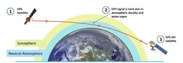
Pyxis will track GPS signals traveling through Earth's atmosphere and convert them into dense, precise measurements of global temperature, pressure and water vapor – similar to data collected by weather balloons but on a global scale – using a technique called GPS Radio Occultation (GPS-RO). Pyxis is the only GPS-RO sensor in such a small package that is powerful enough to routinely probe down into the lowest layers of the atmosphere where severe weather occurs. In addition, Pyxis is able to track signals from all four major satellite navigation systems (GPS, Galileo, Beidou and GLONASS).
PlanetiQ's microsatellite constellation, with an initial set of 12 satellites launching in 2016 and 2017, will deliver over 8 million observations per day of temperature, pressure and water vapor, or more than 10 times the amount of data available from GPS-RO sensors currently on orbit. GPS-RO has shown the highest impact per observation on forecast accuracy among the satellite data sources ingested into computer weather models, and is particularly effective at improving predictions of high-impact weather such as hurricanes, severe weather outbreaks and winter storms. However, the amount of GPS-RO data available to date has been sparse.
The Pyxis sensor development team is based in Boulder, Colo., and led by PlanetiQ Founder Chris McCormick, who was instrumental in designing the sensors on the U.S.-Taiwan Constellation Observing System for Meteorology, Ionosphere, and Climate (COSMIC), the world's first and only satellite constellation of proven GPS-RO sensors.
"The Earth's atmosphere is radically under-sampled at present especially over the oceans which cover 70% of the Earth's surface. With the speed of innovation in sensor technology, space hardware and launch, the weather forecast will dramatically change for the better in the near future," McCormick said. "The Pyxis represents a major step forward in improving forecast accuracy for both routine weather and big storms, while leveraging the latest advances in science, technology and miniaturization to drive down costs."