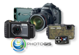
At the Special Operations Forces Industry Conference (SOFIC) 2012, Geo Tactical Solutions, an expert in photo intelligence technology, showcased its range of GPS Photo Intelligence Technology comprising its newest products the G700SE-M tactical GPS camera, PhotoGIS — a photo mapping, analysis, and reporting solution, latest version of Canon EOS digital SLR cameras, GeoMapr SAASM compliant GPS module, and the rugged point-and-shoot GPS cameras with built-in GPS tracking and mapping features.
 The G700SE-M is an ultra rugged GPS-enables digital camera equipped with an array of features specially designed to make collecting accurate and complete photo intelligence easy for the Warfighter.
The President of Geo Tactical Solutions, Matt Kidd explained that the reason for using SOFIC 2012 as a platform to launch its critical intelligence support products is because the greatest demand is from Spec Ops personnel. The SOFIC 2012 also gave Geo Tactical Solutions an opportunity to exchange information about new products and future plans, meet other industry experts, and obtain customer feedback. Kidd added that 2012 has been a good year with strategic partnerships and development of important products.
The G700SE-M Tactical GPS Camera is the flagship product from Geo Tactical Solutions. It is a radical and tough digital camera provided with features such as on-board electronic compass, an advanced SAASM compliant GPS receiver, GPS track-logs and ‘memos’. The camera can effectively collect precise and comprehensive photo intelligence in an easy manner by army personnel, and can be seamlessly connected to a laser range finder for recording GPS coordinates of a remote object within a photo.
The specialty of the GeoMapr is that it can be wirelessly connected via USB cable or Eye-Fi to digital cameras that are compatible with SDHC cards. It provides wider realization of customers’ demands, said Business Development Manager, Andy Shannon. The PhotoGIS will be available at the end of this year, and is designed to allow data integration with the latest GIS applications.